Today's Readers from United States, Canada, Ukraine, Germany and Russia have moved us past the 27,000 PAGEVIEW total for the Nipigon Museum Blog.
Popular Posts to read today have been:
Snowshoe Comparison
High Rises of the Nipigon
A Summer Vacation
Railroad Construction Work 1908
Copper Spears of the Great Lakes
2000 Pageviews
Nipigon River Bungalow Camps
and
Red Rock - the Tug
Most popular Post for the Month :
Nipigon Tramway Construction, Conclusion
Remember you can use the search box in the top left corner to find articles in the Blog.
Thank you for reading about Nipigon area's history.
Tuesday 17 December 2013
Wednesday 27 November 2013
26,164 PAGEVIEWS
THANK YOU READERS FROM AROUND THE WORLD.
The beginning of November we passed 25,000 PAGEVIEWS and I missed getting that up. Now we are nearing the end of November and we are into the 26,000 PAGEVIEWS.
The beginning of November we passed 25,000 PAGEVIEWS and I missed getting that up. Now we are nearing the end of November and we are into the 26,000 PAGEVIEWS.
Wednesday 9 October 2013
24,000 Pageviews just slipped past
Thank you very much for reading the Nipigon Historical Museum's Archives' Blog Posts.
Lots of you are finding answers and some are asking questions that sometimes I can answer.
Lots of you are finding answers and some are asking questions that sometimes I can answer.
Sunday 15 September 2013
23,000 PAGEVIEWS, PASSED
 |
| While I was making apple pies the Pageviews mounted up, so, sometime around last Thursday we passed the 23,000 mark. THANK YOU to all our readers. |
Saturday 24 August 2013
THE SEVEN MEN - GRAVES, MAYBE
.jpg) |
| GRAVES OF SEVEN MEN BLOWN UP IN DYNAMITE ACCIDENT NIPIGON ONTARIO NO DATE GIVEN |
THIS SLIDE WAS JUST SCANNED FROM OUR ARCHIVES . AUGUST 24, 2013
I PRESUME IT GOES WITH THE GRUESOME JOURNEY AND SEVEN MEN FOR ST. MARY'S POSTS
HOWEVER, WE HAVE FOUR CROSSES FROM THAT BURIAL (1909) IN OUR MUSEUM AND THIS PHOTO SHOWS GRAVE STONES.
THE CROSSES WERE IN ST. MARY'S SHED.
NO SEVEN HEADSTONES EXIST IN ST. MARY'S GRAVEYARD. HOWEVER THERE WAS A PROBLEM WITH HEADSTONES FALLING OVER SOME YEARS BACK SO THEY MAY HAVE BEEN REMOVED.
LAKE NIPIGON - OLD PHOTOS
THESE ARE ASSORTED OLD PHOTOS THAT "BUZZ" LEIN COPIED FROM "SOMEWHERE". Notice that Nipigon gets an "e" in place of the first "i".
 |
| NEPIGON CHURCH LAKE NEPIGON |
 |
| CANOES WITH BAGGAGE STARTING OFF LAKE NEPIGON |
 |
| ON THE WAY TO THE WHITE CHUTES |
 |
| NEGIGOOSHTEQUAN, LAKE NEPIGON |
 |
| FLAT ROCK PORTAGE ON LAKE HANNAH TO LAKE NIPIGON |
.jpg) |
| FAMILY IN FRONT OF DWELLING |
 |
| HUDSON BAY COMPANY POST , LAKE NIPIGON |
Thursday 22 August 2013
22,000 PAGEVIEWS AUG. 22, 2013
Thank You readers around the world.
Special thanks to the "Wood Pusher" readers who jumped the Pageviews by a considerable amount this past week.
Welcome to new member D. Hope you continue to enjoy our archives.
Special thanks to the "Wood Pusher" readers who jumped the Pageviews by a considerable amount this past week.
Welcome to new member D. Hope you continue to enjoy our archives.
Tuesday 20 August 2013

Thursday 15 August 2013
NIPIGON MUSEUM NEW MURAL
August 14, 2013 SHOUT MEDIA of Thunder Bay installed the photographic mural on the front of the Nipigon Historical Museum.
Mixing old and new images.
Mixing old and new images.
 |
| Completed mural. |
 |
| People are stopping to look, but will they come inside? We hope. |
Saturday 10 August 2013
NIPIGON 2013 : SOME FUN AND GAMES
 |
| Weighing in the blueberries picked for the annual Blueberry Blast Festival. The first weekend of August. |
 |
| Tents are set up at the Nipigon Marina. |
 |
| Wooden canoe races are held on Sunday. |
 |
| Great scenery, showing Doghead Mountain across the Nipigon River. |
 |
| It is a safe harbour in Nipigon River. |
 |
| The Common Loon checking out the action too. |
NIPIGON - OF ALL PLACES by L.M. (Buzz) Lein
Not dated - Buzz likely wrote this in 1981 as in the 70's Donnie Evans had coined the phrase "Nipigon - of all places" It still pops up even though Nipigon has gone through times of being "Nestled in Nature" to the current brand "The Natural Edge".
NIPIGON - OF ALL PLACES
By L. M. "Buzz" Lein
During the late and unlamented ice age, ice to the depth of a mile and a half piled up over the land of Nipigon. About the only good thing about it was the climate was most discouraging to the blackflies; mosquitoes; sandflies; deer flies and horse flies. Otherwise, Mother Nature did a snow job on a grand scale. Over a period of millions of years the area was scratched, ploughed, shoved, pushed and squashed. All our best dirt was shoved away to the south and is only now coming back via television.
The ice advanced and melted repeatedly. At one time, things were so bad, that if you lived in Chicago, you would have had to carry water about 150 miles because that was how far the water was from the shoreline. It would have served you right for living in that place, because Chicago is a word from the Ojibway and means skunk.
About 10,000 years ago, give or take a few days, somebody got tired of the erratic behaviour of these piles of ice and decreed that, as of at once, there was going to be a change. The temperature increased dramatically in both Fahrenheit and Centigrade degrees. That huge pile of snow and ice cubes turned into floods of melt-water. There were horrible floods and mud all over the place. The water went wherever it could find a place to go. There were probably as many as 8 outlets from Lake Nipigon to Lake Superior to the south. One of these routes follows closely the route selected for Highway 11 from Orient Bay, Ontario to Highway 17 at Nipigon.
The water flowed all over the place. There were creeks, rivulets, rills and rivers in places you wouldn't believe. It was the best of times for mud turtles, frogs and small boys and girls.
After the big melt had been under way for a sufficient period of time, some immigrants showed up from south of the border down Minnesota way. These fellows liked all the mud and water, and not having anything else in particular to do and being short of work -time to qualify for Unemployment Insurance, just stayed around to see what they could see. We don't really know much about these guys. They were here during the period when Lake Superior was considerably higher. They left behind few artefacts along the 800 foot contour level. A few artefacts are occasionally found on the site of the oldest glacial beach just below the terminal moraine on which McKirdy Avenue was built.
(ed.- that's a street in Nipigon)
Some forty-odd years ago when Railway Street was being built and in the area closest to the Nipigon River, the construction workers discovered that they had cut through either an ancient cemetery or a well-lived-in camp site. The Look-out on Railway Street was then ( in glacial melt time) at the water's edge. The construction supervisor saved all the copper artefacts found and is supposed to have sent them to the R.O.M. in Toronto where they got lost in the shuffle. (ed. - No artefacts have ever been located in any museum - and we have searched both by letters and in person)
Meanwhile, the water level in Lake Superior was down again. Cliffside Cemetery and Front Street are both on that geological curiosity known as the Nipissing Beach. It has been accurately dated at 4,000 years old. In 1981 it is approx. 100 feet above the present 602 foot level of Lake Superior. (ed. - talking above sea-level) It will be higher in the future years because this area is still recovering from the pushing down that it got from the glaciers. It will be rising about 50 centimetres per 100 years. So, along with the price of groceries, cars, houses, gas, taxes and clothing, even the ground is going up. It's a good thing the ground is rising, else there would be no place for either the cemetery or Front Street.
About the middle of July, 1500 B.C. the local geography had reached a point when it refused to change anymore, so now what you see is like it was. This means that Nipigon country is a young and immature country. The glacial scars are everywhere. Lake Nipigon and its watery tributaries are also young, geologically speaking. In their present state they are only some 5000 years old. Just think. It only took us about 100 years to ruin both the lakes and the tributaries to say nothing of Lake Superior.
From 1500 B.C. to 1500 A.D. life in the land of the Nipigon was ho-hum. Small bands of Indians camped on the big lakes in the summer; broke up in family sized groups for the winter sports. In the winter they kept warm mostly by chasing caribou and trapping smaller animals so they could use their pelts to keep them warm. The animals did not think highly of this when they thought about it at all. In this same period there were Indians from Lake Nipissing who trekked north to Lake Nipigon for the summer and returned to the sunny south in the fall to harvest whatever crops came up from whatever they planted before they left for the Nipigon.
About this time - 1500 A.D. - north central Ontario was probably Cree country. To the west of Lake Nipigon, the people were probably Assiniboine. At this early date there was evidence that the Ojibway were on the move, coming into the area from the south-east.
No matter where the people lived, the tools and implements that they needed to survive were made of stone. They either had to make these or do without. Spear points, arrowheads, knives, scrapers, pot-smoothers, drills, awls - they made them. Much of it was done artistically.
The writing stops here.
It may seem in the air to a reader, but this is more or less what Buzz would be saying as he toured visitors through the Archaeology Room of our first Nipigon Historical Museum on Second Street.
The visitors would then look over the displays of our "Pre-history Exhibit".
These artefacts survived the fire of 1990 but our new Nipigon Historical Museum on Front Street has display cases rather than rooms.
Wednesday 31 July 2013


Tuesday 30 July 2013
TWO YEARS 21,000 PAGEVIEWS
It doesn't seem that long ago that we started the Blog. It was the beginning of August 2011.
That's 298 Posts ago.
Yesterday, July 29, 2013, was the busiest reading day yet with 211 Pageviews.
Many new readers are discovering our Museum Archives and Nipigon's varied historic past.
In the museum this history resides in a file drawer (many).
Every summer I have the summer student staff read as much as they can so that they can talk about Nipigon's past with our visitors. That is our intangible history... one I can't put in a cabinet for display.
So, now, you in the "world" can access this history of the Nipigon... or as much as I can Post.
Thank You for reading the Nipigon Museum Blog.
Sunday 21 July 2013
A SUMMER VACATION - the conclusion - Nepigon
A SUMMER VACATION ON THE NORTH SHORE OF LAKE SUPERIOR
WRITTEN, ILLUSTRATED AND PUBLISHED BY
W. S. PIPER, FORT WILLIAM, 1918
Nipigon Historical Museum Archives
Three hours later we were anchored in Nepigon Harbor, one of the safest on Lake Superior. It is protected by two peninsulas with three large islands at the entrance forming a breakwater and checking the force of the storms from the south. The east and west is effectually sheltered by high mountains, making this a land-locked harbor.
One of the large islands referred to in the bay is Isle Vert. The Isle Vert stone is well known to the builders of Fort William and Port Arthur and large quantities of this beautiful red sand-stone have been used in both cities. At the mouth of the Nepigon River stands the sacred red rock, sacred to the Manitou. From this rock has been made from time immemorial the Indian Calumet.
The Virgin Falls on the Nepigon River was my destination.
Hiring two guides in Nepigon with canoe and tents, and purchasing provisions, two days later I was comfortably settled in my "Hotel Virgin." My Indians gave me splendid service. Here I met many of the disciples of Izaak Walton and they all agreed that the Nepigon is the first and last word in things piscatorial. A dear old gentleman from New York spent the most of a night with me. He was a student of nature. For the early part of the night the sky was illuminated with the northern lights. Later heavy clouds passed over the sky and from clear spaces the stars burned soft and close and friendly. The gentleman from New York, in his conversation, said that if Nepigon Lake and River was in some remote part of Europe thousands of our American tourists would spend a vast amount of money to see this land of the Otchipaways. The same American tourists would return to the United States and boast for the balance of their lives of the fact that they had visited the Nepigon.
The Nepigon River is famed the world over for its speckled trout and magnificent scenery. It is the largest and clearest river flowing into Lake Superior. It is 42 miles long with numerous lake-like expansions and surging rapids, and is the only outlet from Lake Nepigon. It has an average width of 300 feet, the purest and coldest of water. There are nine portages on it and near those portages the best fishing is to be had. As you canoe the river you get view after view that looks like the climax of wonder, yet another more inspiring one appears.
Lake Nepigon, with its Franco-Indian name, is situated between the parallels of the 49th and 51st degrees of latitude, and the 88th and 89th degrees of longitude; measures nearly 70 miles in length by about 39 miles in width, and in consequence of its numerous and deeply indented bays has a shore line of nearly 600 miles. It is the world's greatest breeding ground of the king of fish, the speckled trout. This beautiful sheet of pure water with its numerous islands was until the exploratory surveys of Canada's great transcontinental railway, the Canadian Pacific, little known to the outside world. It is very deep and has an elevation of 852 feet above sea level. The climate of Lake Nepigon and the North Shore of Lake Superior in summer is much the same as the Florida winter. There are nearly 700 Indians in the Nepigon District. In summer many of them are employed as tourists' guides, while the majority depend almost entirely on fishing and hunting. The government pays them an annual bounty of four dollars per head. It is much to be regretted that in this, their own land, the Indians are actually dying of starvation.
Having fished, explored, and photographed the Nepigon Lake and River, I could now count the remaining days of my vacation on the fingers of one hand. The sun had baked me to a healthy brown , and I could find no excuse to prolong my holiday. With a feeling of regret I packed up and started on my homeward trip. It was evening when we left Lake Helen. The last rays of the setting sun were shining on the Canadian Pacific Railway Company's bridge crossing the Nepigon River as we swept under it into the quiet waters of Nepigon Harbor.
But of all the picturesque routes on the Great Lakes, the inner channel from Nepigon to Thunder Bay is unsurpassed for island scenery. In the early part of the morning the lake gleamed like a mirror, every tree and rock being reproduced in the water.
Passing the Great Thunder Eagle, the lights of Port Arthur and Fort William shone out, making me feel that civilization would soon have me in its grip again.
THE END
The spelling of Nipigon with an 'e' is of historic interest. - nhm
WRITTEN, ILLUSTRATED AND PUBLISHED BY
W. S. PIPER, FORT WILLIAM, 1918
Nipigon Historical Museum Archives
 |
| C. P. R. Bridge crossing the Nepigon River, 1918 |
Three hours later we were anchored in Nepigon Harbor, one of the safest on Lake Superior. It is protected by two peninsulas with three large islands at the entrance forming a breakwater and checking the force of the storms from the south. The east and west is effectually sheltered by high mountains, making this a land-locked harbor.
One of the large islands referred to in the bay is Isle Vert. The Isle Vert stone is well known to the builders of Fort William and Port Arthur and large quantities of this beautiful red sand-stone have been used in both cities. At the mouth of the Nepigon River stands the sacred red rock, sacred to the Manitou. From this rock has been made from time immemorial the Indian Calumet.
The Virgin Falls on the Nepigon River was my destination.
 |
| Virgin Falls, Nepigon River, 1918 |
Hiring two guides in Nepigon with canoe and tents, and purchasing provisions, two days later I was comfortably settled in my "Hotel Virgin." My Indians gave me splendid service. Here I met many of the disciples of Izaak Walton and they all agreed that the Nepigon is the first and last word in things piscatorial. A dear old gentleman from New York spent the most of a night with me. He was a student of nature. For the early part of the night the sky was illuminated with the northern lights. Later heavy clouds passed over the sky and from clear spaces the stars burned soft and close and friendly. The gentleman from New York, in his conversation, said that if Nepigon Lake and River was in some remote part of Europe thousands of our American tourists would spend a vast amount of money to see this land of the Otchipaways. The same American tourists would return to the United States and boast for the balance of their lives of the fact that they had visited the Nepigon.
The Nepigon River is famed the world over for its speckled trout and magnificent scenery. It is the largest and clearest river flowing into Lake Superior. It is 42 miles long with numerous lake-like expansions and surging rapids, and is the only outlet from Lake Nepigon. It has an average width of 300 feet, the purest and coldest of water. There are nine portages on it and near those portages the best fishing is to be had. As you canoe the river you get view after view that looks like the climax of wonder, yet another more inspiring one appears.
Lake Nepigon, with its Franco-Indian name, is situated between the parallels of the 49th and 51st degrees of latitude, and the 88th and 89th degrees of longitude; measures nearly 70 miles in length by about 39 miles in width, and in consequence of its numerous and deeply indented bays has a shore line of nearly 600 miles. It is the world's greatest breeding ground of the king of fish, the speckled trout. This beautiful sheet of pure water with its numerous islands was until the exploratory surveys of Canada's great transcontinental railway, the Canadian Pacific, little known to the outside world. It is very deep and has an elevation of 852 feet above sea level. The climate of Lake Nepigon and the North Shore of Lake Superior in summer is much the same as the Florida winter. There are nearly 700 Indians in the Nepigon District. In summer many of them are employed as tourists' guides, while the majority depend almost entirely on fishing and hunting. The government pays them an annual bounty of four dollars per head. It is much to be regretted that in this, their own land, the Indians are actually dying of starvation.
Having fished, explored, and photographed the Nepigon Lake and River, I could now count the remaining days of my vacation on the fingers of one hand. The sun had baked me to a healthy brown , and I could find no excuse to prolong my holiday. With a feeling of regret I packed up and started on my homeward trip. It was evening when we left Lake Helen. The last rays of the setting sun were shining on the Canadian Pacific Railway Company's bridge crossing the Nepigon River as we swept under it into the quiet waters of Nepigon Harbor.
But of all the picturesque routes on the Great Lakes, the inner channel from Nepigon to Thunder Bay is unsurpassed for island scenery. In the early part of the morning the lake gleamed like a mirror, every tree and rock being reproduced in the water.
Passing the Great Thunder Eagle, the lights of Port Arthur and Fort William shone out, making me feel that civilization would soon have me in its grip again.
 |
| The Great Thunder Eagle of Thunder Cape Sacred to the Manitou The above is an exact reproduction of Thunder Cape, Lake Superior, as shown on U.S. and Canadian Govt. Marine Charts - William S. Piper Copyright 1917 by W.S.P. |
THE END
The spelling of Nipigon with an 'e' is of historic interest. - nhm
Saturday 20 July 2013
A SUMMER VACATION - part 5 - St. Ignace Island
A SUMMER VACATION ON THE NORTH SHORE OF LAKE SUPERIOR
WRITTEN, ILLUSTRATED AND PUBLISHED BY
W. S. PIPER, FORT WILLIAM, 1918
Nipigon Historical Museum Archives
Next morning we left for St. Ignace Island. Lake Superior is famed for its precious stones, and Luke had told me of one of Nanna-Bijou's treasure houses where I might find some agates. Passing Otter Island we encountered a strong south-west wind and headed into it until well out in the lake. Changing our course for Lamb Island we encountered a heavy sea on our quarter aft, the combers picking us up and sending us forward in long intoxicating bounds. In two hours we were in full view of St. Ignace, and, crossing the blind channel, we ran for Green-Mantle -Bay, where we cast anchor.
St. Ignace Island is the second largest island on Lake Superior. It is the granite king-pin of the archipelago of islands, being a breakwater which shelters Nepigon Bay from the fury of the lake. It is a huge rock and has an area of about 160 square miles and is rich in Indian Legends.
Without a pilot one would never find Green-Mantle-Bay. Yet this bay is situated on the south side of St. Ignace Island. It is a crystal basin almost oval, and one could not but marvel at the beautiful transparent water which at a depth of about two fathoms seemed clearer than the atmosphere, the pebbles in the bottom sparkling like opals. There are many such bays on Lake Superior, but none more bewitching than Green-Mantle.
There is also an inner bay which is called the death chamber, deriving its name from the following legend: About two hundred and fifty years ago a Nepigon Chief with his handsome daughter visited at Kaministquia. The dark-eyed beauty won at first sight the heart of a young Kaministiquia brave. She was a true child of nature, passionate and impulsive. For six weeks Green-Mantle and her young brave were constant companions, and parted with the understanding that they would meet soon again. But Fate decided otherwise. Shortly after the Chief's return to Nepigon war was declared on the Sioux. Among the Otchipaway warriors killed, Green-Mantle's lover was numbered among the slain, though the battle ended in a great victory for the Otchipaways. A great festival and dance was afterward held at Rustibou to celebrate the event. The Chief dearly loved his daughter and had presented her with a beautiful shawl which she wore on that occasion, expecting to meet her lover, but on arriving she soon learned the truth. Her heart was crushed and bleeding from the cruel blow. Vainly she strove to rally, but life seemed but an empty blank to her and the merry dance knew her no more. Upon the second night, when the festival was at its height, she quietly disappeared and was not missed until morning. Her canoe was also missing - she had gone to bear her sorrow alone. Two days later a search party found her body lying on the shore in this little bay, rolled in her green shawl, her canoe drawn out of the water. This had been one of her favorite camping grounds. When the lake was calm and the moon shone bright a party of her friends started with her body for Porphyry Island cemetery and laid her by the side of her lover.
They journieyed there in the dead of night,
With their loved one o're the deep,
That she might be laid
In this sacred place
Where parted spirits meet.
_W. S. P.
The next wo days we spent looking for agates. They were all in the solid rock, and the best of them were under water, but I succeeded in getting quite a number of these handsome stones, one of them being a rare gem resembling a human eye, blue in color, with a small tree of gold growing through it. The next day as I stood on the shore of that beautiful bay and looked out on the blue and whiteness of the sky and water, the lure of the sport got me again. Calling Luke, he prescribed Nepigon Straits, and we were soon on our way, casting anchor in the Eagle's Nest, one of Superior's safest harbors.
While at supper we had a call from an Indian and his son. He had some fine speckled trout in the bottom of his canoe that he wanted to trade for pork and tea. I traded with him and gave him some tobacco, although trout were so plentiful now they began to be almost a bore.
After supper I went over to his tepee, as I wanted to hire him and his canoe to take us to a lake on St. Ignace Island that we might troll in the lake and explore same. He refused, however, telling me that he had seen marks on the shore there of a strange animal, one foot being the foot of a man while the other was the foot of something else. I suggested that he show me those marks on our way. After a desultory conversation with the Indian, carried on almost by himself, while he stared into the fire shaking his head, what he did not know about a windigo, or evil spirit, I did when I got through with that interview. Apparently a windigo is the male witch, probably a witch's husband. Getting a description of the place, I visited the shore where the tracks were. He was correct - one foot was that of a man. It was the marks of one who had suffered and offered all that he had that freedom may not die; that the accident of birth shall not give men license to trample over the rights of their fellows. The marks were those of a soldier who had lost a foot.
That afternoon a splendid yacht came down the Nepigon Straits flying the American flag and cast anchor in the Eagle's Nest about a hundred yards from where we lay. We saluted them and was immediately saluted in return. Late I rowed over to call on them and soon felt quite at home with the owner and his party. The owner, by the way, was a true boat lover and was got up regardless of appearance in a suit of blue jeans. After showing me all through his magnificent yacht, I came to the conclusion that it was impossible to tell a wealthy American's Bradstreet rating by his clothes. I soon learned they were from Cleveland and were cruising Lake Superior in a leisurely way for the benefit of the owner's wife who was subject to a severe form of hay-fever. She laughingly informed me that she had not had a sneeze since entering Lake Superior, which was certainly remarkable, for among her friends in Ohio she was known as the "seventeen times sneezer." They were anxious to go trout fishing, so I invited them over to my cruiser and presented them with about ten pounds of speckled trout with which they were delighted. We spent three delightful days fishing and cruising and visiting the Wana-Wana Falls, Duncan's Cove, and the reefs of St. Ignace Island. In the evening we were entertained with their splendid phonograph. But I must see Lake Nepigon, and it was with a feeling of regret that we pulled anchor and bid good-bye to our friends. As we sailed down the Nepigon Straits they played that beautiful song:
"I'll take you home again Kathleen,
Across the ocean wild and wide."
TO BE CONCLUDED - The Nepigon adventure
WRITTEN, ILLUSTRATED AND PUBLISHED BY
W. S. PIPER, FORT WILLIAM, 1918
Nipigon Historical Museum Archives
 |
| Lamb Island and Light |
Next morning we left for St. Ignace Island. Lake Superior is famed for its precious stones, and Luke had told me of one of Nanna-Bijou's treasure houses where I might find some agates. Passing Otter Island we encountered a strong south-west wind and headed into it until well out in the lake. Changing our course for Lamb Island we encountered a heavy sea on our quarter aft, the combers picking us up and sending us forward in long intoxicating bounds. In two hours we were in full view of St. Ignace, and, crossing the blind channel, we ran for Green-Mantle -Bay, where we cast anchor.
St. Ignace Island is the second largest island on Lake Superior. It is the granite king-pin of the archipelago of islands, being a breakwater which shelters Nepigon Bay from the fury of the lake. It is a huge rock and has an area of about 160 square miles and is rich in Indian Legends.
Without a pilot one would never find Green-Mantle-Bay. Yet this bay is situated on the south side of St. Ignace Island. It is a crystal basin almost oval, and one could not but marvel at the beautiful transparent water which at a depth of about two fathoms seemed clearer than the atmosphere, the pebbles in the bottom sparkling like opals. There are many such bays on Lake Superior, but none more bewitching than Green-Mantle.
 |
| Green-Mantle-Bay |
There is also an inner bay which is called the death chamber, deriving its name from the following legend: About two hundred and fifty years ago a Nepigon Chief with his handsome daughter visited at Kaministquia. The dark-eyed beauty won at first sight the heart of a young Kaministiquia brave. She was a true child of nature, passionate and impulsive. For six weeks Green-Mantle and her young brave were constant companions, and parted with the understanding that they would meet soon again. But Fate decided otherwise. Shortly after the Chief's return to Nepigon war was declared on the Sioux. Among the Otchipaway warriors killed, Green-Mantle's lover was numbered among the slain, though the battle ended in a great victory for the Otchipaways. A great festival and dance was afterward held at Rustibou to celebrate the event. The Chief dearly loved his daughter and had presented her with a beautiful shawl which she wore on that occasion, expecting to meet her lover, but on arriving she soon learned the truth. Her heart was crushed and bleeding from the cruel blow. Vainly she strove to rally, but life seemed but an empty blank to her and the merry dance knew her no more. Upon the second night, when the festival was at its height, she quietly disappeared and was not missed until morning. Her canoe was also missing - she had gone to bear her sorrow alone. Two days later a search party found her body lying on the shore in this little bay, rolled in her green shawl, her canoe drawn out of the water. This had been one of her favorite camping grounds. When the lake was calm and the moon shone bright a party of her friends started with her body for Porphyry Island cemetery and laid her by the side of her lover.
They journieyed there in the dead of night,
With their loved one o're the deep,
That she might be laid
In this sacred place
Where parted spirits meet.
_W. S. P.
The next wo days we spent looking for agates. They were all in the solid rock, and the best of them were under water, but I succeeded in getting quite a number of these handsome stones, one of them being a rare gem resembling a human eye, blue in color, with a small tree of gold growing through it. The next day as I stood on the shore of that beautiful bay and looked out on the blue and whiteness of the sky and water, the lure of the sport got me again. Calling Luke, he prescribed Nepigon Straits, and we were soon on our way, casting anchor in the Eagle's Nest, one of Superior's safest harbors.
 |
| At Eagle's Nest, Nepigon Straits |
While at supper we had a call from an Indian and his son. He had some fine speckled trout in the bottom of his canoe that he wanted to trade for pork and tea. I traded with him and gave him some tobacco, although trout were so plentiful now they began to be almost a bore.
After supper I went over to his tepee, as I wanted to hire him and his canoe to take us to a lake on St. Ignace Island that we might troll in the lake and explore same. He refused, however, telling me that he had seen marks on the shore there of a strange animal, one foot being the foot of a man while the other was the foot of something else. I suggested that he show me those marks on our way. After a desultory conversation with the Indian, carried on almost by himself, while he stared into the fire shaking his head, what he did not know about a windigo, or evil spirit, I did when I got through with that interview. Apparently a windigo is the male witch, probably a witch's husband. Getting a description of the place, I visited the shore where the tracks were. He was correct - one foot was that of a man. It was the marks of one who had suffered and offered all that he had that freedom may not die; that the accident of birth shall not give men license to trample over the rights of their fellows. The marks were those of a soldier who had lost a foot.
That afternoon a splendid yacht came down the Nepigon Straits flying the American flag and cast anchor in the Eagle's Nest about a hundred yards from where we lay. We saluted them and was immediately saluted in return. Late I rowed over to call on them and soon felt quite at home with the owner and his party. The owner, by the way, was a true boat lover and was got up regardless of appearance in a suit of blue jeans. After showing me all through his magnificent yacht, I came to the conclusion that it was impossible to tell a wealthy American's Bradstreet rating by his clothes. I soon learned they were from Cleveland and were cruising Lake Superior in a leisurely way for the benefit of the owner's wife who was subject to a severe form of hay-fever. She laughingly informed me that she had not had a sneeze since entering Lake Superior, which was certainly remarkable, for among her friends in Ohio she was known as the "seventeen times sneezer." They were anxious to go trout fishing, so I invited them over to my cruiser and presented them with about ten pounds of speckled trout with which they were delighted. We spent three delightful days fishing and cruising and visiting the Wana-Wana Falls, Duncan's Cove, and the reefs of St. Ignace Island. In the evening we were entertained with their splendid phonograph. But I must see Lake Nepigon, and it was with a feeling of regret that we pulled anchor and bid good-bye to our friends. As we sailed down the Nepigon Straits they played that beautiful song:
"I'll take you home again Kathleen,
Across the ocean wild and wide."
TO BE CONCLUDED - The Nepigon adventure
Friday 19 July 2013
A SUMMER VACATION Part 4, Otter Island
A SUMMER VACATION ON THE NORTH SHORE OF LAKE SUPERIOR
Written, illustrated and published by
W. S. Piper , Fort William, 1918
Nipigon Historical Museum Archives
On awakening next morning we found the lake in a very obstreperous mood. Lake Superior is a large lake and certainly does things in a large way. One could not believe her temper could get so ruffled in a few hours. No reef fishing today, the water was jumping far above the reefs.
That afternoon I trolled in vain in the bay. Many a time I hauled in my line expecting I had hooked a maskilonge (muskellunge) or sturgeon, only to find my catch was a stick of pulp wood or a bunch of weeds.
There was a beautiful pink sunset that evening, so we decided to leave for Rustibou in the morning. We were not particularly early risers when cruising, but perhaps I was the demoralizing influence.
It was noon when we dropped anchor in Lambs' Bay. I was anxious to explore Rustibou, as Luke had told me there were relics to found there of a bloody encounter that took place between the Sioux and Otchipaways. I was anxious to find a copper arrow-head, but was not successful, although I found a flint one in perfect condition. The arms used in battle were guns, bows and arrows, and the swatter or bludgeon. The Sioux ammunition gave out and the Otchipaways defeated them with their favorite weapon, the swatter, exterminating the whole band. The extinct races found in the tumli, or mounds, of North America seem all to have suffered from the same weapon. Luke's great great grandfather, then a young brave, fought in the battle of Rustibou.
In the evening we left for Otter Cove, one of the finest harbors on Lake Superior for pleasure boats. After casting anchor, we rowed up to near the falls and cooked supper on the river bank. Talk about beautiful scenery - it was magnificent; the falls with their banks of spruce and birch made a picture long to be remembered.
During supper I found we had camped at Mosquito Lodge, and it proved to lodge night, and they seemed to have got me for the goat, as Luke seemed undisturbed. After supper and washing up, I was glad to return to the boat to escape the flies. Stretching out on the cockpit cushions I lit a cigar; a great peacefulness stole over me, and I lost all desire to move. The soft fragrance of the air and the murmuring sound of the falls all seemed to sooth my mind as I gazed dreamily at the reflection made by the moon on the water. I suppose I dozed off, but awakened half-conscious of something splashing near by. Swimming toward the boat was a large moose. I watched it with genuine pleasure. There is something delightful in meeting these interesting people of the wilds. Suddenly it raised its sensitive nose, and sniffing suspiciously in my direction, caught the danger scent, and immediately swam for the shore and disappeared in the bush.
Next morning as the big red sun was pushing its way above the eastern rim of the lake, I slowly and with great care made my way to near the foot of the falls. When within about two rods length of the goal I then cast a fat pink worm into the water. It seemed to scarcely sink beneath the surface when there was a great commotion on the end of my line. I landed for breakfast four beautiful trout.
I fished no more that day, as I did not wish to catch more than we could use. That evening I strolled up the Otter River above the falls, finding an old lumber road. I walked farther than I intended, and sitting down on a log that crossed the river or creek, I watched intently for some time for signs of fish, but was surprised to see no fish or animal life of any kind, not even flies. It was a pleasant evening and time passed quickly. The sun had dropped behind the hills and darkness suddenly came on, when almost instantly a crashing in the brush arrested my attention. A red deer went flying past me toward the lake, seeming scarcely to touch the ground. I at once made for the trail, walking fast. I had a feeling that I was not alone; the bush seemed to be alive with the patter of feet. I was not afraid, but more than startled on seeing the form of a large timber wolf ahead of me. Raising his sepulchral voice, he called his companions, and was immediately answered on all sides and for miles around. Striking a few matches, I pressed on toward the lake, never slackening my pace till I saw the welcome light of the camp fire.
NEXT; LEAVING FOR ST. IGNACE ISLAND
Written, illustrated and published by
W. S. Piper , Fort William, 1918
Nipigon Historical Museum Archives
 |
| No Reef Fishing Today |
On awakening next morning we found the lake in a very obstreperous mood. Lake Superior is a large lake and certainly does things in a large way. One could not believe her temper could get so ruffled in a few hours. No reef fishing today, the water was jumping far above the reefs.
That afternoon I trolled in vain in the bay. Many a time I hauled in my line expecting I had hooked a maskilonge (muskellunge) or sturgeon, only to find my catch was a stick of pulp wood or a bunch of weeds.
There was a beautiful pink sunset that evening, so we decided to leave for Rustibou in the morning. We were not particularly early risers when cruising, but perhaps I was the demoralizing influence.
It was noon when we dropped anchor in Lambs' Bay. I was anxious to explore Rustibou, as Luke had told me there were relics to found there of a bloody encounter that took place between the Sioux and Otchipaways. I was anxious to find a copper arrow-head, but was not successful, although I found a flint one in perfect condition. The arms used in battle were guns, bows and arrows, and the swatter or bludgeon. The Sioux ammunition gave out and the Otchipaways defeated them with their favorite weapon, the swatter, exterminating the whole band. The extinct races found in the tumli, or mounds, of North America seem all to have suffered from the same weapon. Luke's great great grandfather, then a young brave, fought in the battle of Rustibou.
 |
| "Rustibou" |
In the evening we left for Otter Cove, one of the finest harbors on Lake Superior for pleasure boats. After casting anchor, we rowed up to near the falls and cooked supper on the river bank. Talk about beautiful scenery - it was magnificent; the falls with their banks of spruce and birch made a picture long to be remembered.
 |
| Otter River and Falls |
During supper I found we had camped at Mosquito Lodge, and it proved to lodge night, and they seemed to have got me for the goat, as Luke seemed undisturbed. After supper and washing up, I was glad to return to the boat to escape the flies. Stretching out on the cockpit cushions I lit a cigar; a great peacefulness stole over me, and I lost all desire to move. The soft fragrance of the air and the murmuring sound of the falls all seemed to sooth my mind as I gazed dreamily at the reflection made by the moon on the water. I suppose I dozed off, but awakened half-conscious of something splashing near by. Swimming toward the boat was a large moose. I watched it with genuine pleasure. There is something delightful in meeting these interesting people of the wilds. Suddenly it raised its sensitive nose, and sniffing suspiciously in my direction, caught the danger scent, and immediately swam for the shore and disappeared in the bush.
 |
| Otter Island |
Next morning as the big red sun was pushing its way above the eastern rim of the lake, I slowly and with great care made my way to near the foot of the falls. When within about two rods length of the goal I then cast a fat pink worm into the water. It seemed to scarcely sink beneath the surface when there was a great commotion on the end of my line. I landed for breakfast four beautiful trout.
I fished no more that day, as I did not wish to catch more than we could use. That evening I strolled up the Otter River above the falls, finding an old lumber road. I walked farther than I intended, and sitting down on a log that crossed the river or creek, I watched intently for some time for signs of fish, but was surprised to see no fish or animal life of any kind, not even flies. It was a pleasant evening and time passed quickly. The sun had dropped behind the hills and darkness suddenly came on, when almost instantly a crashing in the brush arrested my attention. A red deer went flying past me toward the lake, seeming scarcely to touch the ground. I at once made for the trail, walking fast. I had a feeling that I was not alone; the bush seemed to be alive with the patter of feet. I was not afraid, but more than startled on seeing the form of a large timber wolf ahead of me. Raising his sepulchral voice, he called his companions, and was immediately answered on all sides and for miles around. Striking a few matches, I pressed on toward the lake, never slackening my pace till I saw the welcome light of the camp fire.
NEXT; LEAVING FOR ST. IGNACE ISLAND
Thursday 18 July 2013
A SUMMER VACATION part 3
A Summer Vacation on the North Shore of Lake Superior
Written, illustrated and published by
W.S. Piper, Fort William, 1918
Nipigon Historical Museum Archives
The morning broke clear with a nice breeze off the land, so I asked Luke concerning fishing for speckled trout. He said: "As there is a breeze blowing we had better not try for trout off the reefs, but sail out on deep water and put out the troll." But for the trout of the reefs I protested feebly. "Oh, no, Mister, too many nets here; I will take you later where you will get speckled trout." this was decided on, so I started the engine and we were soon clear of the islands, and, when well out on the deep water, I shut down and hoisted the sail. For three hours I trolled, catching three silver and one gray trout. By this time I felt highly elated and remarked to Luke, "Some catch, eh?" "Not bad, Mister." But I felt worthy of more applause.
Turning toward the shore I beheld a peculiar formation. The peninsula that divides Black Bay from Sturgeon Bay, called Magnet Point, seemed to take the form of a human Hercules, the head lying slightly lower than the body, the breasts very prominent, the limbs partly covered with water, and feet protruding. At one time the Indians blamed this formation for all their trouble. it is a common saying among Indians to this day that when an Indian does wrong that he should be sent to Matchee-Manitou to scratch his feet. This is supposed to typify Satan, the old serpent. On how he came to make Magnet Point his resting place authorities differ. According to one of the legends, he made war against Nanna- Bijou, a servant of the great Manitou, and was seriously wounded. This provoked the wrath of the old serpent, who, hoping to destroy Nanna-Bijou and all the animal creation, entered into the water and blowing his venom into it, caused the oceans to boil up and overflow the land. Nanna-Bijou, seeing the waters rising, built a great raft, saving with it a species of all animal life. After the water subsided, Matchee-Manitou, in the form of a great giant, appeared on Lake Superior. As he approached the Great Thunder Eagle he was struck by lightning, and , falling across Magnet Point, his back was broken, thus forming the strange formation.
As we neared the No. 10 Lighthouse the keeper ran down to the water's edge and hailed us. I thought it was an S. O. S. and that something was wrong, so we turned in. His delight was truly pathetic, as no one had called there for eight weeks. He asked about the war and other current events, and one seldom gets such an appreciative audience. We gave him some newspapers, fruit and cigars, and spent a couple of hours pleasantly on the island, leaving with the feeling that we had never known how glad one could be for the mere presence of human companionship.
We then ran for the old Hudson Bay harbor where we cast anchor.
Taking the tender we rowed to the reefs about two miles off where the water was deep and blue - blue as a sapphire. I handled with care my two new and expensive fishing rods which were accompanied by numerous different flies. I knew I had been extravagant and I gloried in it. Carefully adjusting a large brown hackler to my line, I cast, keeping my fly in the air and winging it about like a thing alive. I lightly deposited my offering on the crystal platter, which was immediately accepted. I had hooked a coaster. On feeling the metal in his mouth he made for the open lake, sending my reel spinning. Suddenly my line slackened; he leaped from the water. I reeled in, then let it spin out; his dashes for freedom being most beautiful. After playing him for almost twenty minutes he began to tire and Luke landed him with the net. he was a lovely speckled trout 18 inches long. I hooked two more that evening 14 inches long and packed them in a box of moss covered with ice.
TO BE CONTINUED
Written, illustrated and published by
W.S. Piper, Fort William, 1918
Nipigon Historical Museum Archives
 |
| Old Silver Islet Mine, 1918 |
 |
| Silver Islet Summer resort, 1918 |
The morning broke clear with a nice breeze off the land, so I asked Luke concerning fishing for speckled trout. He said: "As there is a breeze blowing we had better not try for trout off the reefs, but sail out on deep water and put out the troll." But for the trout of the reefs I protested feebly. "Oh, no, Mister, too many nets here; I will take you later where you will get speckled trout." this was decided on, so I started the engine and we were soon clear of the islands, and, when well out on the deep water, I shut down and hoisted the sail. For three hours I trolled, catching three silver and one gray trout. By this time I felt highly elated and remarked to Luke, "Some catch, eh?" "Not bad, Mister." But I felt worthy of more applause.
Turning toward the shore I beheld a peculiar formation. The peninsula that divides Black Bay from Sturgeon Bay, called Magnet Point, seemed to take the form of a human Hercules, the head lying slightly lower than the body, the breasts very prominent, the limbs partly covered with water, and feet protruding. At one time the Indians blamed this formation for all their trouble. it is a common saying among Indians to this day that when an Indian does wrong that he should be sent to Matchee-Manitou to scratch his feet. This is supposed to typify Satan, the old serpent. On how he came to make Magnet Point his resting place authorities differ. According to one of the legends, he made war against Nanna- Bijou, a servant of the great Manitou, and was seriously wounded. This provoked the wrath of the old serpent, who, hoping to destroy Nanna-Bijou and all the animal creation, entered into the water and blowing his venom into it, caused the oceans to boil up and overflow the land. Nanna-Bijou, seeing the waters rising, built a great raft, saving with it a species of all animal life. After the water subsided, Matchee-Manitou, in the form of a great giant, appeared on Lake Superior. As he approached the Great Thunder Eagle he was struck by lightning, and , falling across Magnet Point, his back was broken, thus forming the strange formation.
 |
| Nanna-Bijou, the Sleeping Giant of Thunder Cape, 1918 |
As we neared the No. 10 Lighthouse the keeper ran down to the water's edge and hailed us. I thought it was an S. O. S. and that something was wrong, so we turned in. His delight was truly pathetic, as no one had called there for eight weeks. He asked about the war and other current events, and one seldom gets such an appreciative audience. We gave him some newspapers, fruit and cigars, and spent a couple of hours pleasantly on the island, leaving with the feeling that we had never known how glad one could be for the mere presence of human companionship.
We then ran for the old Hudson Bay harbor where we cast anchor.
Taking the tender we rowed to the reefs about two miles off where the water was deep and blue - blue as a sapphire. I handled with care my two new and expensive fishing rods which were accompanied by numerous different flies. I knew I had been extravagant and I gloried in it. Carefully adjusting a large brown hackler to my line, I cast, keeping my fly in the air and winging it about like a thing alive. I lightly deposited my offering on the crystal platter, which was immediately accepted. I had hooked a coaster. On feeling the metal in his mouth he made for the open lake, sending my reel spinning. Suddenly my line slackened; he leaped from the water. I reeled in, then let it spin out; his dashes for freedom being most beautiful. After playing him for almost twenty minutes he began to tire and Luke landed him with the net. he was a lovely speckled trout 18 inches long. I hooked two more that evening 14 inches long and packed them in a box of moss covered with ice.
TO BE CONTINUED
Wednesday 17 July 2013
SUMMER VACATION, part 2
A Summer Vacation on the North Shore of Lake Superior
Written, Illustrated and Published by
W. S. Piper, Fort William, Ontario, 1918
Nipigon Historical Museum Archives
We are now entering Kitchegamee (Lake Superior), the great fresh water reservoir of North America, which has an area of 31,800 square miles, its greatest length being 420 miles and its greatest width 167 miles. Its maximum depth is 1000 feet, and its surface is 600 feet above the level of the sea. Its lowest floor is about 400 feet below the sea level. The temperature of the lake in summer is about 39 degrees Fahr., and falls from 4 to 5 degrees in winter
Looking from the southwest we get a good view of the Lion of Thunder Cape, the highest elevation forming the head and breast.
As we sail down the southeast shore we pass Moos-oos (Moose Calf) of Thunder Cape.
We are now in sight of Silver Islet, one of Nanna-Bijou's treasure houses. From it has been taken over four millions of dollars. The old Silver Islet village is now a popular summer resort. We did not call at the Islet, as our destination was Porphyry, but, slowing down, I took several pictures while passing.
Another hour saw us anchored in Porphyry Harbor where the most ancient cemetery on Lake Superior is situated and which is known as the Indian's Happy Hunting-ground. At the entrance to the harbor stands the sacred rock "Shaminitou" (Child Saviour), sacred to the Manitou, and from time immemorial the recipient of special offerings by its devotees. Pictures of this peculiar rock may be seen on the Pacific coast and in Alaska, carved on wood and on totem poles.
We spent the evening exploring the island and visited the cemetery. The last burial on Porphyry was in the year 1884. Luke explained to me the reason this most beautiful place is no longer used. The Indian belief is that when he dies he goes to the happy hunting-ground, where all kinds of game abounds, but the Christian religion appeals more to the younger generation, many of them claiming to belong to same, while others, although not strictly adhering to ancient customs, are decidedly free thinkers. In many cases their greatest need is food and clothing.
As it was a quiet, peaceful night we sat up late, and nature and God seemed very good. We were loath to go to bed, but, after adjusting our riding light, we turned in. We had not been long asleep when we were suddenly awakened by a loud hoarse noise which seemed to almost lift us out of bed and rip to shreds the silence of the wilderness. It was the Porphyry fog-horn. This started the night birds to quaver out all sorts of petulant lost-soul cries; blaming someone or something for disturbing their slumbers and shriekingly resenting the intrusion. This Gabriel continued to trumpet most of the night and seemed to put a crowning touch on this weird place.
Written, Illustrated and Published by
W. S. Piper, Fort William, Ontario, 1918
Nipigon Historical Museum Archives
We are now entering Kitchegamee (Lake Superior), the great fresh water reservoir of North America, which has an area of 31,800 square miles, its greatest length being 420 miles and its greatest width 167 miles. Its maximum depth is 1000 feet, and its surface is 600 feet above the level of the sea. Its lowest floor is about 400 feet below the sea level. The temperature of the lake in summer is about 39 degrees Fahr., and falls from 4 to 5 degrees in winter
Looking from the southwest we get a good view of the Lion of Thunder Cape, the highest elevation forming the head and breast.
As we sail down the southeast shore we pass Moos-oos (Moose Calf) of Thunder Cape.
 |
| The Lion of Thunder Cape |
 |
| Moose -oos of Thunder Cape |
We are now in sight of Silver Islet, one of Nanna-Bijou's treasure houses. From it has been taken over four millions of dollars. The old Silver Islet village is now a popular summer resort. We did not call at the Islet, as our destination was Porphyry, but, slowing down, I took several pictures while passing.
Another hour saw us anchored in Porphyry Harbor where the most ancient cemetery on Lake Superior is situated and which is known as the Indian's Happy Hunting-ground. At the entrance to the harbor stands the sacred rock "Shaminitou" (Child Saviour), sacred to the Manitou, and from time immemorial the recipient of special offerings by its devotees. Pictures of this peculiar rock may be seen on the Pacific coast and in Alaska, carved on wood and on totem poles.
 |
| The Sacred Rock "Shaminitou" |
We spent the evening exploring the island and visited the cemetery. The last burial on Porphyry was in the year 1884. Luke explained to me the reason this most beautiful place is no longer used. The Indian belief is that when he dies he goes to the happy hunting-ground, where all kinds of game abounds, but the Christian religion appeals more to the younger generation, many of them claiming to belong to same, while others, although not strictly adhering to ancient customs, are decidedly free thinkers. In many cases their greatest need is food and clothing.
As it was a quiet, peaceful night we sat up late, and nature and God seemed very good. We were loath to go to bed, but, after adjusting our riding light, we turned in. We had not been long asleep when we were suddenly awakened by a loud hoarse noise which seemed to almost lift us out of bed and rip to shreds the silence of the wilderness. It was the Porphyry fog-horn. This started the night birds to quaver out all sorts of petulant lost-soul cries; blaming someone or something for disturbing their slumbers and shriekingly resenting the intrusion. This Gabriel continued to trumpet most of the night and seemed to put a crowning touch on this weird place.
 |
| Porphyry Cemetery |
 |
| Porphyry Light and Number 10 Light |
Tuesday 16 July 2013
A SUMMER VACATION
A SUMMER VACATION ON THE NORTH SHORE OF LAKE SUPERIOR
WRITTEN, ILLUSTRATED AND PUBLISHED BY WILLIAM S. PIPER
FORT WILLIAM, ONTARIO
1918
Nipigon Historical Museum Archives
INTRODUCTION
We in Western Algoma are just beginning to realize the charm of Indian Legends. Too late, perhaps, as many of the old-time Otchipaways, who translated freely, have passed away. By pen and camera I have tried to preserve some of their stories as told to me years ago. There is an unmistakable charm about Indian legends that is fascinating, especially when you hear them amid their own surroundings.
W. S. P.
A SUMMER VACATION ON THE NORTH SHORE OF LAKE SUPERIOR
With thermometer registering almost 90 degrees in the shade I wasted no time, but took a hasty farewell of my friends. Taking one last look around my office, I found so many things that required my personal attention, that I left immediately. Since my vacation was to be aquatic, I made straight for the dock, where I found Luke, my Indian pilot, awaiting me at the head of navigation on the Kaministiquia.
Among the principal rivers flowing into Lake Superior the Kaministiquia as a commercial River ranks first. Born in the height of land, or watershed, dividing the waters of the Hudson Bay from those of Lake Superior, its valley is the only railway outlet between Thunder Bay district and the Canadian Northwest, the three transcontinental railways following its course to near the summit of the great divide. The river banks are very beautiful, in many places the river winding between shores of spruce and birch with here and there luxuriant banks of wild roses fringed with water lilies. Some of the largest stock and diary farms in the district are situated on the Kaministiquia River. Two miles down we pass the old Point de Mueron farm, atone time the residence of the late Lord and Lady Milton, and the birthplace of the present Lord Milton.
As we sailed down the river I asked Luke concerning "Kaministiquia." He said the Chippewa word "Kaministiquia" meant in English "river of many mouths." After a ten-mile run we entered the Fort William harbor where elevators succeed elevators - elevators of steel, elevators of concrete, elevators of wood - with freight boats of all kinds receiving grain at their spouts. At the wheel Luke was kept busy passing scows, barges, tugs and every imaginable kind of water-craft.
It was high noon when we left the river and entered into the clear water of Thunder Bay. Here Luke explained to me the Indian Legend of Thunder Bay as follows:
"Many, many years ago a party of hunters from a distant tribe, in spite of many warnings, provoked the wrath of the Great Thunder Eagle by climbing to its summit and assailing its home in the high cliff. Their progress was suddenly arrested by vivid flashes of lightning accompanied by loud and prolonged peals of thunder. The mountain was soon enveloped in flames and the hunters all perished in the vain attempt to bring down a great medicine. Ever after the bay on which the cities of Fort William and Port Arthur are situated was known as Thunder Bay."
We are now in full view of Port Arthur. It is situated on a hill and is one of Canada's most beautiful cities and a popular summer resort. But when on a vacation I want birds and butterflies overhead, not buildings, as brick, stone and human faces look much alike the world o'er, so we changed our course for the Welcome Islands, where many, many years ago one of the fiercest battles ever fought took place between the Sioux and Otchipaways, traces of which remain.
To the east of us is the Great Thunder Eagle of Thunder Cape, upon whose western side reclines Nanna-Bijou, the Sleeping Giant. The inspiration of the Great Thunder Eagle, sacred to the Manitou, from time immemorial swayed the minds of the extinct races who peopled this land of the Algonquins, as well as the Indians of the present time. Pictures of it may be found in this district and the far north carved on the rocks and in the mounds of the extinct races. All the sacred animals are represented by Thunder Cape as described by St. John, Rev. 4 - 7.
As we passed Hare Island we could see and hear a bell buoy. The channel was marked right enough, but about the way the old lady marked her pies: "T. M. " ('tis mince ) and "T. M. " ('tisn't mince ). There was nothing to indicate which side of the bell buoy to go, but the chart showed plenty of water either side.
TO BE CONTINUED AS MR. PIPER HEADS INTO LAKE SUPERIOR ON HIS WAY TO NEPIGON.
WRITTEN, ILLUSTRATED AND PUBLISHED BY WILLIAM S. PIPER
FORT WILLIAM, ONTARIO
1918
Nipigon Historical Museum Archives
 |
| front cover |
 |
| Victoria Avenue, Fort William, 1918 |
 |
| Cumberland Street, Port Arthur, 1918 |
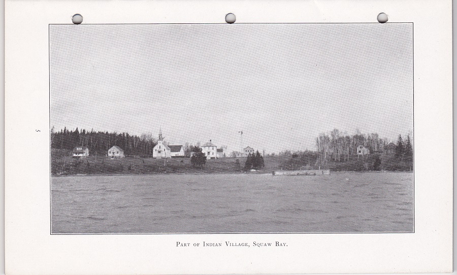 |
| Part of Indian Village, 1918 |
 |
| Nepigon Village, 1918
|
 |
| Birch Park, 600 Acre Farm on Kaministiquia River, 1918 |
 |
| Bowlker Park, 780 Acre Dairy Farm on Kaministiquia River, 1918 |
 |
| W. S. Piper, 500 Acre Stock Farm on Kaministiquia River, 1918 |
 |
| Kakabeka Falls, on the Kaministiquia River, 1918 |
INTRODUCTION
We in Western Algoma are just beginning to realize the charm of Indian Legends. Too late, perhaps, as many of the old-time Otchipaways, who translated freely, have passed away. By pen and camera I have tried to preserve some of their stories as told to me years ago. There is an unmistakable charm about Indian legends that is fascinating, especially when you hear them amid their own surroundings.
W. S. P.
A SUMMER VACATION ON THE NORTH SHORE OF LAKE SUPERIOR
With thermometer registering almost 90 degrees in the shade I wasted no time, but took a hasty farewell of my friends. Taking one last look around my office, I found so many things that required my personal attention, that I left immediately. Since my vacation was to be aquatic, I made straight for the dock, where I found Luke, my Indian pilot, awaiting me at the head of navigation on the Kaministiquia.
 |
| Piper's boat |
Among the principal rivers flowing into Lake Superior the Kaministiquia as a commercial River ranks first. Born in the height of land, or watershed, dividing the waters of the Hudson Bay from those of Lake Superior, its valley is the only railway outlet between Thunder Bay district and the Canadian Northwest, the three transcontinental railways following its course to near the summit of the great divide. The river banks are very beautiful, in many places the river winding between shores of spruce and birch with here and there luxuriant banks of wild roses fringed with water lilies. Some of the largest stock and diary farms in the district are situated on the Kaministiquia River. Two miles down we pass the old Point de Mueron farm, atone time the residence of the late Lord and Lady Milton, and the birthplace of the present Lord Milton.
 |
| Fort William Harbour |
As we sailed down the river I asked Luke concerning "Kaministiquia." He said the Chippewa word "Kaministiquia" meant in English "river of many mouths." After a ten-mile run we entered the Fort William harbor where elevators succeed elevators - elevators of steel, elevators of concrete, elevators of wood - with freight boats of all kinds receiving grain at their spouts. At the wheel Luke was kept busy passing scows, barges, tugs and every imaginable kind of water-craft.
It was high noon when we left the river and entered into the clear water of Thunder Bay. Here Luke explained to me the Indian Legend of Thunder Bay as follows:
"Many, many years ago a party of hunters from a distant tribe, in spite of many warnings, provoked the wrath of the Great Thunder Eagle by climbing to its summit and assailing its home in the high cliff. Their progress was suddenly arrested by vivid flashes of lightning accompanied by loud and prolonged peals of thunder. The mountain was soon enveloped in flames and the hunters all perished in the vain attempt to bring down a great medicine. Ever after the bay on which the cities of Fort William and Port Arthur are situated was known as Thunder Bay."
We are now in full view of Port Arthur. It is situated on a hill and is one of Canada's most beautiful cities and a popular summer resort. But when on a vacation I want birds and butterflies overhead, not buildings, as brick, stone and human faces look much alike the world o'er, so we changed our course for the Welcome Islands, where many, many years ago one of the fiercest battles ever fought took place between the Sioux and Otchipaways, traces of which remain.
To the east of us is the Great Thunder Eagle of Thunder Cape, upon whose western side reclines Nanna-Bijou, the Sleeping Giant. The inspiration of the Great Thunder Eagle, sacred to the Manitou, from time immemorial swayed the minds of the extinct races who peopled this land of the Algonquins, as well as the Indians of the present time. Pictures of it may be found in this district and the far north carved on the rocks and in the mounds of the extinct races. All the sacred animals are represented by Thunder Cape as described by St. John, Rev. 4 - 7.
As we passed Hare Island we could see and hear a bell buoy. The channel was marked right enough, but about the way the old lady marked her pies: "T. M. " ('tis mince ) and "T. M. " ('tisn't mince ). There was nothing to indicate which side of the bell buoy to go, but the chart showed plenty of water either side.
 |
| Port Arthur Harbour, 1918 |
Subscribe to:
Posts (Atom)