Monday 29 December 2014

FISHING PRESSURE 1962


ACTION NEED(ED) NOW - 1962

L.M.”Buzz” Lein, writing as J.P. Savage

From Nipigon Historical Museum Archives:

“One of these years we are going to become unpleasantly aware of the fact that the fish population in our area will be on the decrease.  This isn’t going to happen right away, nor in five years, but it is going to happen. Then, we will sit around and weep large round tears, watery remembrances of better days past.

Why are the fish going to become less numerous?  Fishing pressure and a lack of basic knowledge of fish farming.  It is that easy.

At present in the area people are fishing in virgin waters and there are not too many fishing on a per square mile of water basis.  As the area opens up and more roads are built, more people can get into previously unfished lakes.  The number of fishermen is increasing yearly whereas the area of fishing water isn’t.

There is only one thing to do – increase the yield of fish per acre of water.

This is easy to say, but very difficult to do because no one knows what to do.  And no one is going to know what to do because no one is doing anything.

What about lampreys?

As viewed from here, this is another classic example of locking the door after the horse is stolen.  Up until the time money income from lake trout started a spectacular decline, the lamprey was an unpleasant parasite whose presence was deplored and ignored.

It is not probable that the lamprey-type threat will occur in the large inland lakes of Northwestern Ontario although it is possible that Lake Nipigon may some day be infected. But it highly probable that fishing pressure at some future date will reduce the fish population to the point where an angler will keep his fishing tackle as an interesting reminder of what used to be.

It isn’t necessary to permit all this.  It isn’t even necessary to let the fish population be wiped out.  What is necessary is a quick start on the factors influencing the growth and yield of these delightful aquatic denizens.

But, if anyone is doing any biological research along these lines it is a well-kept secret and secrets aren’t kept long in Northwestern Ontario.  Therefore, it is assumed that there is no specific research.

What should be done now is to have a corps of biologists out through the district working at biology and not being game wardens as well.  If such a corps were out working on specific problems, on specific locations, something might be learned.  It wouldn’t be learned cheaply, nor would it be learned quickly, but it would be learned. Once the biologists discovered what should be done, a practical program to carry this out could be started.

The big question right now is when is something constructive  going to be done, and on a scale that will be produce results?”

Written for the Times Journal , June 1962.

LAKE NIPIGON COMMERCIAL FISHING


Nipigon Historical Museum Archives: L.M. “Buzz” Lein Research Files, 1978

Excerpts from: Canadian Geographic Aug/Sept 1978

Page 62

Commercial Fishing in Northern Ontario, by George Adams

“Commercial fishing started on Lake Nipigon as early as 1898 but wasn’t important until about 1910…

…with the continuance of favourable prices and successful establishment of better market conditions in the early 1900’s the industry expanded considerably.

Indicative of the active interest in commercial fishing  at this time was a 20 year lease that the Canada Fish Company negotiated in 1902 with the Province of Ontario for rights to fish Lake Nipigon.

The conditions of the lease, at $15,000 per year included a railway to the lake to be built by the company.  The fishing license  in this lease allowed 500 tons annually for the first three years and twice that amount for each year thereafter. Fortunately the full conditions of this license were not utilized.

Originally open water commercial fishing was confined almost entirely to lakes near suitable transportation.  The construction of the National Transcontinental across the top of Lake Nipigon gave access after 1907 to lakes in the formerly remote area.”

NIPIGON TROUT, EDWARD R. HEWITT 1934


NIPIGON TROUT, EDWARD R. HEWITT  1934

Letter from Edward R. Hewitt, New York, N.Y.

To: Mrs. Girvan, April 17, 1934.

Copy in Nipigon Museum Archives

My dear Mrs. Girvan:

I am very familiar with the Nipigon country having made two trips there.  On the last trip I happened to be there at the end of the season when the Indians were catching their winter fish.  I arranged with them to let me catch them  the fish and I started in and caught all they needed.  They would have taken them anyway.  I got 1500 trout over 3 and a half pounds and 65 over 6 pounds.  I had one 28 inches long and 28 inches girth which would have weighed about 14 pounds.  I saw five trout on this trip which were cleaned which weighed from ten to 12 and a half pounds – their insides were removed when I weighed them.

A friend of mine on the Canadian Survey in 1879 got one near the mouth of the Nipigon weighing 19 and one half pounds. This is recorded in the survey.

At the top of the Virgin Falls I got 13 fish one day none of which was under six pounds and one of them 14 pounds and another 8 and three quarter pounds.  This was in 1889.

I have also gotten a great many along the shore of Lake Superior but they were rarely over 6 and a half pounds and rather blue in color.

It would give me great pleasure to see that country again but I fear I will not get there and my old wild place is spoiled anyway.  I would not care to visit it now.

Signed, Edward R. Hewett ( 9spelling keeps changing)

NIPIGON TROUT, KNIGHT TO CLARK 1938


NIPIGON TROUT,  KNIGHT TO CLARK 1938

Letter from the Nipigon Museum Archives:

From John Alden Knight of Orange New Jersey

To: Gregory Clark, Toronto Star,  August 5, 1938

Dear Greg;

While chatting with you in your library this summer, I was interested in looking over a copy of a letter from Edward R. Hewitt, wherein he declines, with the usual Hewitt abruptness, an invitation to fish the Nipigon.  In that letter he mentions quite casually the taking of some large trout at the top of the Virgin Falls in that river.

Now you have seen the Virgin Falls and you can understand what would happen to a man who might have the ill fortune to be carried over them. He treats the taking of those monster trout quite casually in his letter.  I have heard him tell the story several times at the Anglers’ Club luncheon table and I thought you would like to have it as I remember it.

The trout referred to were easily to be seen lying with their tails almost at the lip of the falls, completely out of casting range from the shore.  Using very heavy tackle, so that the fish could be held from going over the falls when hooked, Hewitt had himself maneuvered into the centre of the pool above the falls by means of fastening two long ropes to the prow of a canoe.  The ropes were then snubbed around trees by Indain Guides, one on each bank.  I believe that he used as a lure a piece of trout belly with the fin attached.  And there, hanging on the brink of eternity, he hooked and landed several of those huge fish.

Truly, he is an amazing old man.

Yours,

John Alden Knight

Monday 24 November 2014

NIPIGON SNOW FALLS OF THE PAST

PHOTOS BY E.C.EVERETT
Nipigon Museum Archives

Not sure the date on these.


With the CPR Water Tower , 1969.

Wednesday 19 November 2014

50,000 PAGEVIEWS SINCE AUGUST 2011

If you were looking at the Nipigon Museum Blog yesterday, November 18, 2014 , you were instrumental in making our tally of Pageviews reach the 50,000 mark.

We started the year 2014 at 27,555 Pageviews .

A very big thank you to all the old and new readers from across the globe.

Saturday 8 November 2014

BUZZ LEIN'S - PULP PIONEERS OF RED ROCK

In place of earlier link that didn't work.

Written by L.M. (Buzz) Lein February 25, 1974

Thirty-eight years ago (1936) a bleached kraft mill took shape and substance on the northwest shore of Nipigon Bay on Lake Superior. Closed down by financial problems before it could get rolling in 1938, it just sat there until the Brompton Pulp and Paper Company acquired the property in 1942, and started to turn out kraft paper on a converted newsprint machine some two years later.

During the early 1950's, the St. Lawrence Corporation became the operating company and so remained for about ten years.

In 1961, St. Lawrence Corporation merged with Dominion Tar & Chemical and Domtar Limited began its career on the north shore of Lake Superior.

From its start-up early in 1944 and through 1951, statistics are (un)fortunately scarce, but during this period the mill was producing about 250 tons of brown paper per day, six days a week. All the wood required was delivered in log form, nearly all by water during spring and summer. Some 130,000 cords of softwood were consumed yearly. The softwood was about 70% spruce and 30% jackpine.

During 1952 - 53, there was a milestone expansion. A new kraft paper machine was installed and the old one put back into newsprint service. In addition, facilities were added that would permit, for the first time, the use of poplar to make a pulp.

1953 also saw the arrival of the first consignment of wood chips. These were purchased from Great Lakes Lumber & Shipping in Thunder Bay and amounted to about 4,800 tons for the year. 1953 was the year for another first - 6 cords of poplar purchased from John Dampier of Nipigon and water delivered to the mill at Red Rock.

When the new kraft machine went into action in 1954 and with the newsprint machine running, production of paper jumped from 87,000 tons to 153,000 tons in 1955.  The big increase was in newsprint where from start-up production of 11,000 tons in 1954 it ballooned to 50,000 tons in 1955.  The delivery of wood to Red Rock followed the paper production pattern, From 115,000 cords in 1954, the jump was to 163,000 cords in 1955.

By this time the paper production pattern and wood delivery program was wet.  Over the following six years, not much change was evident. Kraft paper production was about 100,000 tons a year, newsprint 56,000 tons while into this was going about 224,000 cords a year of spruce, balsam, jackpine and poplar.  Spruce and balsam still made up 70% of the material with jackpine forming nearly all of the rest. The percent of poplar was quite small in relation.

In 1962, Domtar's mill began operating on a seven-day week and is still doing this in 1974. This immediately created more jobs, provided increased security for a paper based economy and increased yearly production by about 18,000 tons of paper. By year end 1963, annual paper production was now 195,000 tons per year.

More was to come. In 1964, the capacity of the sulphate mill was increased and major changes were made in the paper machines.  Production of paper was up again by 15,000 tons to 210,000 tons yearly.

Why sawmills and paper mills need each other

A change is noticed in the type of material from which the paper was being made. From a timid beginning with 4,800 tons of chips in 1954, ten years later in 1964, the tonnage of chips had worked its way up to 80,000 tons.  At this period, softwood chips were sawmill residue and it is to Domtar's credit that their people were willing and able to pioneer a process then regarded as daring in wood fibre use. The beneficial economic affect on the distant saw mill producers of chips may well have been incalculable because chips were their cash crop at a time when cash was scarce.

A major mill improvement program was again announced in 1969. This time, the emphasis was on pollution abatement with many in-plant improvements.

1969 saw the hesitant beginning of a new process to use another type of sawmill residue in the making of pulp. 133 oven dry tons of sawdust were purchased. This was in addition to the 165,000 tons of chips, 197,000  O.D.T. of limit wood and 7,800 O.D.T. of poplar chips that were used to produce 253,000 tons of paper.

By 1970, with the construction program on the go, millions were spent on a primary effluent treatment plant, revised wood handling facilities to eliminate the river drive of pulpwood to the mill, and to set up facilities to utilize some 100,000 tons of sawdust per year.

The effect of the 1970-72 improvements were best evident by the production for the year 1973 when kraft paper production was up to 210,000 tons; newsprint to 68,000 tons for a total of 278,000, the most paper Domtar's mill at Red Rock has ever produced.

And, to do this, it required 146,000 O.D.T. of roundwood ( 8 foot logs from Domtar limits), 195,000 O.D.T. of chips from out-lying sawmills, 94,000 O.D.T. of sawdust from far away sawmills, and 21,500 O.D.T. of poplar chips from two area plywood mills.

What stability of community looked like.

In the manufacture of paper, one does not progress by maintaining the status quo.  Already plans are being made for increased production that will go along with more efficient use of available fibre, mill operations that will be in harmony with the environment and processes that will foster the stability that has been in the area ever since that first mill started up on the shores of Nipigon Bay some thirty odd years ago.

Today we do not have stability

(2012 the mill sits dormant., gutted by salvage, but Red Rock still has hope.)

Sunday 2 November 2014

A POSSIBLE FUTURE THAT NEVER HAPPENED


Editorial

From: The Evening News-Chronicle, Port Arthur, Ontario

April 24, 1942   Page 4

Intimation has been given recently that an important war industry is to be located in Manitoba.

Since this war began (the) attitude of The News-Chronicle generally has been that  there should be no interference with or pressure of any kind used on government authorities  to the end that particular areas benefit by necessary war industry but, in this case, it does look as if the government might find it more profitable to consider the Nipigon area for its new enterprise than the proposed site in Manitoba.

The Winnipeg Free press, discussing the plans for what it describes as a $100,000,000 war plant, admits that there are difficulties with regard to power supply to be overcome in the Province.  It says “ To get the plant Winnipeg has to show that it can supply a minimum of 80,000 horse power of electrical energy.  This Winnipeg cannot do at the present .”

The Winnipeg paper then goes on to discuss the alternatives, describing the Seven Sisters development as one of the most practicable.  But even there, according to the same authority, it would be necessary to spend $5,000,000 blasting out rock.  The Free Press says “If many thousands  of tons of rock were removed the generating capacity of the Seven Sisters plant could be increased by 50,000 horse power without the installation of additional equipment.  Neither the City Hydro nor the Winnipeg Electric Company now has funds available to finance these undertakings.  It is assumed that if, as and when  the government decides to build in Winnipeg it will arrange to help finance the power plant extensions.”

The Nipigon power area, which includes Port Arthur, could present a much more attractive picture than that.  An additional 100,000 horse power could be developed on the Nipigon River with much less expenditure than apparently necessary in Manitoba.  It would not be necessary to blast out $5,000,000 of rock for a dam at available and now unused falls.  Only a fraction of that blasting would be necessary for the building of a dam and the remainder could be used for installation of equipment,  so that the power seems much more available on the Nipigon.

Furthermore, much of the raw material for the plant proposed in Manitoba is apparently to be brought into the country. Nipigon or the Port Arthur area because of their harbors could offer shipping attractions which are not available in Manitoba.

Furthermore, if the plan is to scatter the essential industries Nipigon still has it attractions.

Tuesday 23 September 2014

WORDS TO " ROCK PAINTING 2"


In memory of Selwyn Dewdney (1909 – 1979), artist, teacher, novelist, psychiatric therapist, and Canada’s foremost researcher of Indian Rock Art. He grew up in Northwestern Ontario where he saw his first pictograph and over his lifetime he recorded hundreds more for the National Museums of Canada, Glenbow Foundation, Royal Ontario Museum, and the Quetico Foundation.

Selwyn wrote more than 20 books and articles on Indian art including Indian Rock Paintings of the Great Lakes with Kenneth Kidd and Sacred Scroll of the Southern Ojibway in collaboration with James Red Sky of Shoal Lake. A graduate of the University of Toronto, he was Research Associate in the office of the Chief Archaeologist, Royal Ontario Museum.

His brilliant achievements made him Canada’s “father of rock art research”.


The following words go with the rock paintings of the previous Posts. Archaeology of Northwestern Ontario  2 Indian Rock Paintings and Carvings.

Page 4

The hundreds of Indian rock art sites adorning our cliffs and rock slopes supply elements of reverence and mystery to the Northwestern Region’s beautiful lakes.

The paintings, or “pictographs”, are figures in bright red pigment made from mineral haematite 9red ochre) and possibly a grease and glue from sturgeon fish.  They are nearly always found on spectacular, vertical, cliff faces at the water’s edge.

The carvings, or “petroglyphs”, are figures much like the painted ones but incised with a sharp tool or pecked with a blunt object onto smooth rock slopes along the shoreline.  In our region they have been found only on Lake of the Woods and may be related to the petroglyph sites in northern Minnesota.

WHO WERE THE ARTISTS?

The Canadian Shield in Northern Ontario, Manitoba and Saskatchewan was populated as early as A.D. 1000 by the Algonkian-speaking ancestors of the modern Cree and Ojibway people. Many of the figures on the rock paintings and carvings are similar to those on nineteenth and twentieth century Ojibway birch bark scrolls.

HOW OLD ARE THEY?

We have not discovered techniques to date the sites. We can only guess at their age from the objects depicted. Petroglyph sites in northern Minnesota have been dated to as early as 3,000 B.C. because they depict atlatls, or spear throwers, which were used during the Archaic period (about 3,000 B.C. to 200 B. C. ). Some of the Lake of the Woods petroglyphs may date to that period, although others have been incised with modern metal instruments. The rock paintings may date to as early as A.D. 1000 – that is, the beginning of the period recognizably ancestral to the modern Cree and Ojibway – but we know that some are historic because they depict European-introduced items such as the horse and rifle.

Page 5

WHY WERE THEY PAINTED?

A Manitoba researcher was told the following story by Crees at Oxford House, a tale that gives us some notion as to why the paintings were done:

Page 7

A woman of Oxford House Band was very sick.  The woman’s family asked an old man named Mistoos Muskego to come and cure her of her illness.  The old man tried again and again to cure the woman but nothing seemed to work.  Finally the old man said that there was only one hope left and that was to go and ask the men who lived in the rock if they could give him the powerful medicine needed to cure the woman.  The old man left in his canoe and paddled to where he knew they dwelt.  (This spot is today a granite rock face rising sharply upwards from the Semple River even as it was in Mistoos’ day.)  The old man was very powerful and used his power to enter the rock, into the home of the men who lived there.  The old man talked for a long time with the men who lived in the rock and asked for the medicine that would cure the woman, and in the end he was given the medicine that he requested.  The old man then left the rock and paddled back to the home of the woman who was ill.  The medicine of the men who lived in the rock was given to the woman who was ill.   This medicine cured the woman.  The old man said that all should remember it was the men who lived in the rocks who were powerful and could give medicine to a powerful old man.  The old man then made a paint and asked all the people to come with him to the mome of the men who lived in the rocks.  The old man and the people then paddled  their canoes up to the rock ledge by the water.  He told the assembled people how he had  received the medicine.  He then said that no one should forget the men who lived in the rock and that he would draw a painting of them. (He then drew a painting about two feet high, stick-figured with lines running from the head giving a “rabbit-eared” look.)  The people now would remember where the men who lived in the rock lived and what they looked  like, and all returned home.

Clint Wheeler, CRARA Newsletter (Manitoba Chapter) 1:4

Page 8

The man who told the researcher the story had heard it from his grandmother, and her grandmother had been present, as a little girl, at the painting.

The above story links the painting to Cree Medicine and similar paintings may be an element also of Ojibway Medicine. Researchers have noted distinct similarities between the painted figures and the forms on birch bark scrolls of the Ojibway Midewiwin, or Grand Medicine Society.

WHAT DO THEY MEAN?

Many of the figures are executed in such an abstract fashion that it is difficult to recognize them.  Some are distinguishable as bear, moose, bison, etc., but some are simply generalized animal or human figures.  The abstract and symbolic figures makes interpretation difficult without access to the original artists. Indeed, the artists may have preferred abstractions so that only they knew what the paintings meant.

We can see that on many paintings there are groups of figures probably telling a story.  The Algonkian concept of spatial organization is not a left-to-right progression as in writing but a generalized grouping of forms as in a picture.  The figures, if they were meant to be used in the same manner as those on the birch bark scrolls, were meant simply as memory aids for the shaman-artist to recall a story – historical or mythological or both – related to the area where the painting was done.  The above recollection from Oxford House describes such a situation.

It is likely that each site has not one but several meanings depending on the audience.  Ojibway writer Basil Johnston has pointed out that Ojibway stories are not to be interpreted literally but have four depths of meaning: enjoyment, moral teaching, philosophic, and metaphysical.  Readers draw their own  inferences according to their knowledge and abilities.  The same is likely true of the rock art sites.

Page 9

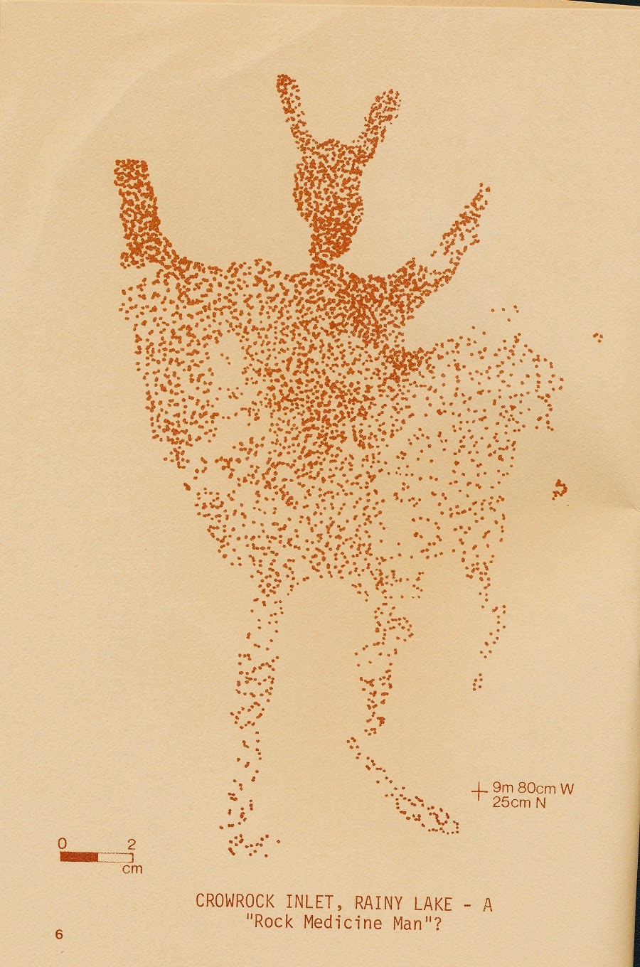
Some figures may be spirits – the upraised arms of the human figures denote the spiritual quality perhaps of Maymaygwayshi, or Rock Medicine Men, who live in the cliffs and are known to steal fish from nets and bother Indians canoeing by the site, but they also have positive qualities as the Oxford House story relates.

Page 10

The animal figures are probably not only the ephemeral catch of the hunt but also the ethereal spirits of the Species – the Spirit Bear, the Spirit Wolf, etc. , who allow the Indians to kill animals for food and who have prominent roles in the Midewiwin both as spirit guardians and guides but sometimes as threats, depending on their positive or negative roles.

HOW SHOULD THE SITES BE TREATED?

The Indian rock art sites are considered by many Cree and Ojibway to be sacred and offerings are still left for the spirits at many sites in the Northwestern Region. The pictographs and petroglyphs are also valuable archaeological records of past Indian Cultures and therefore, under The Ontario Heritage Act, 1974, it is illegal to deface a rock art site, under penalty of up to $5,000 and/or up to two years in jail.

The sites should be treated with care and respect. DO NOT TOUCH THE ROCK PAINTINGS. Human perspiration can break down the bond between rock and paint. Do not use an abrasive such as sand, in the rock carvings to get a clear outline. The sand will eventually wear away the rock and destroy the carving.

TIPS FOR PHOTOGRAPHY  (pre-digital)

1)      Use ASA 64 film for colour slides or prints.

2)      For pictographs, try for a slightly overcast day: one that is bright, but not sunny. Sun tends to produce a glare on the rock face and too much shade produces pictures that are too dark with unnatural purplish tints in the pigment.

3)      “Bracket” the f-stop setting on the camera. If your light metre calls for an f-stop of 8, take shots also at 5.6 and at 11 to make sure you get a good picture.

4)      For petroglyphs, visit the sites either early in the morning or late in the afternoon to get slanted sunlight on the rock slope that creates deep shadows in the figures and makes them visible.  Overhead sun blots out the figures. Page 11


Page 12

FOR MORE INFORMATION

The Canadian Rock Art Research Associates (CRARA), founded by the late Selwyn Dewdney, is a group of amateur researchers and professional archaeologists dedicated to the preservation of Canada’s Indian rock paintings and carvings and to the dissemination of information on the subject.

Department of Anthropology and Archaeology

University of Saskatchewan,

Saskatoon, Saskatchewan

S7N 0W0


The Regional Archaeologist’s Office, Northwestern Region, Historical  Planning and Research Branch, Ontario Ministry of Culture and Recreation, has recorded many of the rock art sites of the region

207 First Street South

Box 2880

Kenora, Ontario

P9N 3K8


FOR FURTHER READING

Dewdney, Selwyn, Indian Rock Paintings of the Great Lakes.  University of Toronto Press

Dewdney, Selwyn. Sacred Scrolls of the Southern Ojibway.  University of Toronto Press.

Studies in West Patricia Archaeology Nos. 1 and 2.  Edited by C.S. Paddy Reid. Toronto: Historical Planning and Research Branch, Ontario Ministry of Culture and Recreation. (Archaeology Research Report series.)


Page 34

HERITAGE CONSERVATION

Archaeological sites are fragile heritage resources containing society’s only source of information about most of its past.  Broken bits of pottery and arrowheads are more than interesting curios – they are important fragments  of scientific evidence.  Urban development, highway construction, and thoughtless artifact collectors are destroying this evidence at an alarming rate.


It is the responsibility of the Historical Planning and Research Branch, Ontario Ministry of Culture and Recreation, to identify and preserve archaeological and historical resources.  This aim can be achieved only with the help and support of all citizens of the Province. For further information please contact the Regional Archaeologist in your area.

Sunday 31 August 2014

continuing INDIAN ROCK PAINTINGS 2

BLOODVEIN RIVER  (detail)
0  to 10 cm
JACKFISH LAKE NEAR RAINY LAKE

JACKFISH LAKE NEAR RAINY LAKE

CUTTLE LAKE LARGE SITE NEAR RAINY LAKE
0  TO 2CM
2m 3cm above rock ledge

CROWROCK INLET, RAINY LAKE
TOP   0  TO 2cm
10m  50cm W
38cm N
BOTTOM  0  to 2cm
10 m 50cm W
15 cm N

The booklet list Petroglyphs of Sunset Channel, Lake of the Woods and another site near Zigzag Island , Lake of the Woods. No way could I scan these photos as they were all reddish on reddish.

RED LAKE
0  to 15cm

BERENS RIVER
0  to 5cm

BERENS RIVER
0  to 5cm

PUKAMO ISLAND, RAINY LAKE
0  to 5cm
320 cm above water level June 24, 1979
CROWROCK INLET,  RAINY LAKE
Datum: 86cm above water level, August 21, 1979.
0 to 2cm

CROWROCK INLET, RAINY LAKE
0 to 2cm
8m  39cm W
46cm N
 
CUTTLE LAKE SMALL SITE NEAR RAINY LAKE
0  to 2cm
PICTURE ROCK ISLAND, LAKE OF THE WOODS
0  to 10cm
PICTURE ROCK ISLAND, LAKE OF THE WOODS
0  TO 10cm
PICTURE ROCK ISLAND, LAKE OF THE WOODS
0 to 10 cm

DEER LAKE

Saturday 30 August 2014

INDIAN ROCK PAINTINGS 2

THE ARCHAEOLOGY OF NORTHWESTERN ONTARIO
2
INDIAN ROCK PAINTINS AND CARVINGS
MINISTRY OF CULTURE AND RECREACTION HISTORICAL PLANNING BRANCH
C. 1980
Hon. Reuben C. Baetz   Minister
Dr. Douglas Wright   Deputy Minister
ISBN 0-7743-5583-2


The Cuttle Lake Large Site Near Rainy Lake

Crowrock Inlet, Rainy Lake - A "Rock Medicine Man?"
 
Annie Island, Lake of the Woods

0 to 25cm
 
Pineneedle Lake
0  to 15 cm

Blindfold Lake
0  to 10 cm

Bloodvein River
0  to 50 cm
I will continue the rock art in the next post.

Sunday 17 August 2014

LAW OF THE LAND, 1925


GOVERNING THE SUPERIOR GAME PRESERVE, DISTRICT OF THUNDER BAY


( Extract from the Ontario Gazette of Saturday, November 7th, 1925)

COPY OF AN ORDER- IN- COUNCIL, APPROVED BY THE HONOURABLE THE LIEUTENANT – GOVERNOR, DATED  THE 30TH DAY OF OCTOBER, A.D. 1925.

Upon the recommendation of the Honourable the Minister of Mines, the Committee of Council advise that, pursuant to the provisions of clause (g) of Section 8 of The Ontario Game and Fisheries Act, it shall be unlawful to hunt, take, pursue, kill, wound, destroy or have in possession any bird or animal, or be in possession of any firearm of any description on the territory described below, and such territory to be created as a Crown Game Preserve, and designated as “The Superior Game Preserve;” such lands being more particularly described as follows:

All the territory in the District of Thunder Bay situate and lying south of a point located at the mouth of the Black Sturgeon River where it enters Black Bay east of the Village of Hurkett, thence along the eastern bank of the river to the Canadian National Railway to a point on the Nipigon Bay known as Red Rock, thence easterly to the rock quarries located at the mouth of the Nipigon River south of the Village of Nipigon, thence following the shore line of the main land to a point due south of the westerly boundaries of the Village of Schreiber, together with the waters of Black Bay and all the islands therein.

The provisions of this Regulation shall not apply to any officer of the Department of Game and Fisheries who may be given a special permit to carry firearms and to kill predatory animals and vermin on the Preserve, or take animals for educational, scientific or propagation purposes; provided, however, that the District Warden may issue a permit to have firearms in possession and to take all water fowl, during the regular open season, on the waters of Lake Superior and bays thereof, within the territories of the above Preserve.

The Committee further advise that the Order-in-Council, dated the 21st day of October, 1924, governing the “Superior Game Preserve,” be revoked.

Certified,

(signed) C. F. Bulmer,

Clerk, Executive Council.

Saturday 16 August 2014

SCHOOLS OF THE AREA

JELLICOE SCHOOL 1925
JELLICOE SCHOOL 1935

STURGEON RIVER GOLD MINE, SCHOOL
NEZAH  CNR 11 MILES
MISS HEBDEN, 1941

STURGEON RIVER GOLD MINE SCHOOL, 1941

COLDWELL SCHOOL, 1936
MISS POWELL, TEACHER


ALL PHOTOS BY E.C. EVERETT, NIPIGON

Friday 15 August 2014

George Nicholson's LIFE IN THE NIPIGON DISTRICT


By: L.M. “Buzz” Lein

When Buzz wrote this sometime in the early 1980’s (likely 1983) , George Nicholson was alive, therefore the title:

GEORGE NICHOLSON – LIVING HISTORY

‘Someone once asked me how we found all these stories that we share with our readers. The answer is simply that we don’t – the stories find us.  As is the case with the one you are about to read.”

“If you recall, we wrote about a shipwreck on  Lake Nipigon in 1910.  This sparked a special interest in a Red Rock resident.  We were invited to communicate with him because he said that he knew quite a bit about those old boats that steamed up and down Lake Nipigon.”

“We did just that.  Not only did we meet an extremely nice gentleman but we added immensely to our Nipigon story.  You are reminded that we had no idea  who we were going to meet, and a vague idea of what we were going to talk about.”

“Meet George Nicholson of Red Rock.  This grey haired gentleman in his 88th year (as near as we can tell) is fluently bilingual.  He has spent his life in the Nipigon dIstrict;  has done everything he had to do  to survive and while he may have some regrets about some of the things that happened to him he is not bitter about the way life has treated him.  He has an excellent memory for bygone days and speaks about the past with an easy flow of language that would put many a university student to shame.”

“George Nicholson was born on the south end of Ignace Island at a place called by him “Burnt Harbour”.  We cannot find this spot on any of our maps. Since George’s birth was not recorded, he has only hearsay to go on when asked how old he is.  But backtracking in time from some things he told us, it was either 1895 or 1896.”

“While in Burnt Harbour, his mother died and his father presumably, decided tomove into Nipigon where there would be someone that could look after the baby better than he could.  But on the way in to Nipigon, the boat that was carrying them piled up on a rock and sank. No lives were lost but they had to row all the  back to Burnt Harbour to get some help.”

“Our guess is that Burnt Harbour was the headquarters for a group of commercial fishermen who abounded throughout this area about this point in time.  They arrived in Nipigon finally – at Red Rock as it was known in those days.  They disembarked at Nicholson’s Landing.  We think this is  the place where John Dampier  built his little cabin.  On the East bank opposite the Red Rock Post. But the Nicholson family were burnt out and had to move again.”

“ By this time George’s father was working on construction of the Revilllon Bros. post in Ombabika Bay at the north end of Lake Nipigon.  Taking a guess we would say this was about 1907 or 1908.  The Nicholson family then moved into this post and lived there while George’s father worked on the steamer Ombabika.”

“This boat was a steamboat and was fired with wood at the start – switched over to coal as the Nipigon Tramway came into service and could haul coal into South Bay. This Ombabika, by the way, was built at South Bay about 1906 from a kit that was made up and hauled into South Bay over winter roads.  This also was a Revillon  Boart.”

Revillon also built a motorized Scow, powered by steam. It was a big brute and had a shallow draught for getting heavy loads close to shore.  This one was the real workhorse of the Lake carrying hay, oats, horses, men and anything else that could be loaded on board.”

“It carried the material needed by the North Transcontinental to build their railroad across the top of Lake Nipigon.  Today it is part of the C.N.R. from Winnipeg to Montreal.”

“It was the Minewa that attracted George’s attention when he heard about the article we wrote on the 1910 shipwreck at Scherburn Island.  And we were wondering where the heck this Island was because we had never heard of it.”

By the way, in Ojibway, Minewa means “going back and forth.” Somewhat irreverently, we like the word “Yo-yo” better.”

“Anyway, the reason that Nicholson knew why the 1910 newspaper reported got the name of the boat wrong;  why the name of the Island was wrong;  why the location was incorrectly reported – was that George Nicholson  himself was on board the Minewa when the Captain piled it up on Flatlands Is..”

“This latter is north westerly from the mouth of the Sturgeon River about nine miles. It well deserves its name.  George, at the time was 14 or 15 years old and was sort of a roustabout on the scow. His father was also working on the craft at the same time.”

“Anyway, that Minewa was grossly overloaded with so much hay piled up in the front of the craft that visibility was much curtailed. It wouldn’t have mattered if that day had been calm and sunny – but it wasn’t.  It was snowing to beat hell the way it can do on Lake Nipigon and you couldn’t see 50 feet in any direction.”

“Now the Minewa had a shallow draught and was darn close to shore when they crunched on the bottom.  Probably sprang a small leak and since they couldn’t move, the scow just sat there and filled up. There were a couple of yawl boats and a whole crew of men on board so they scrambled off; un-loaded all the food they needed and just waited out the weather.”

“Sure enough as soon as the weather cleared – probably the next day – the Ombabika on her way north spotted the disabled craft and came to the rescue.  The Ombabika probably took most of the men back to South Bay, along with the Minewa Captain, Nicholson Sr. was left in charge.”

“By the time the Insurance investigation was complete – and by the way, that long ago reporter got the adjuster’s name right at least. George Rapsy. When all this was cleared up, the water transport was over for the year  and  George’s father took him to Ombabika Bay; ran in as far as the ice would let him and dumped  the young  fellow off and told him to hike home to the Revillon Post.  Obviously he made it all right.”

“George spent the winter of 1910-1911 freighting over the ice from South Bay to the Tramway terminus in Ombabika Bay. With freighting from South Bay to the Tramway terminus in Ombabika Bay complete;  the Nicholsons moved again, this time to South Bay where Nicholson Sr. became the Captain on another little steamer called  the “Pewabic” (iron) and moved freight from South Bay to MacDiarmid for the construction of the Canadian Northern.”

“George’s father worked for the Ontario Forestry Branch out of MacDiarmid for 36 years, mostly running the boat “Ogima” – (‘chief’ in Ojibway) - .  Abitibi had a boat by this name on Lake Nipigon, but it wasn’t this one – theirs was the Ogima II. It’s  at Oscar Styffe’s dock in Port Arthur.”

“George was now living at Sand Point which was the settlement  that preceded MacDiarmid. He worked for a while fishing on Lake Nipigon; worked for the railway as a section man and did whatever he had  to do to make a living.”

“ In those days there was no unemployment insurance and if you didn’t work, you didn’t get any money. Since work on the railway and fishing was seasonal employment a guy had to be nimble footed indeed to remain gainfully employed. Especially in and around Lake Nipigon.”

“We think that Nicholson freighted on the construction of the C.N.R. from MacDiarmid to Longlac but we have to talk to him about this. We were amused at one remark that George made about the time he was living and freighting out of South Bay and that was about the presence of a “whiskey” policeman there. He knew the guy’s name – it was Van Norman. Ring a bell? Van Norman Street in Port Arthur? His job was to check all northbound people for the possession of alcohol.  Van Norman must have confiscated dozens of bottles.  We often wonder where all those old whiskey bottles around Lake Nipigon came from. – Van Norman sure as heck didn’t get them all.”

“We also note A. M. Lower in his short description of going north on Lake Nipigon in 1909 mentions provincial policemen at South Bay checking one and all for the presence of liquor.”